Ero sivun ”Cellmapper/FAQ/fi” versioiden välillä
(Ak: Uusi sivu: == What are "low accuracy" towers? ===) |
(Ak: Uusi sivu: Low accuracy towers are towers whose location cannot be accurately predicted given the uploaded data. Therefore, they revert to a more simple algorithm of placing the tower closest...) |
||
| Rivi 30: | Rivi 30: | ||
== What are "low accuracy" towers? === | == What are "low accuracy" towers? === | ||
| − | + | Low accuracy towers are towers whose location cannot be accurately predicted given the uploaded data. Therefore, they revert to a more simple algorithm of placing the tower closest to the location of the best signal strength. This will usually be significantly less accurate than the triangulation method normally used. Some towers that only have 1 or two cells, such as omnidirectional towers, will always be low accuracy. Likewise, any towers which were detected with weaker signals will also be low accuracy until stronger signal samples are uploaded. | |
=== Mikä on "Estimate Frequency"? === | === Mikä on "Estimate Frequency"? === | ||
Versio 5. lokakuuta 2015 kello 10.00
Tähän sivulle tulee usein kysytyjä kysymyksiä Cellmapperistä.
Sisällysluettelo
The tower location is way off/in the middle of the water/on top of a remote mountain
Tower locations are based purely on calculations. The reason that towers will show up over water is due to the fact that water usually doesn't contain any object that can block signals. So, to the algorithm, sitting in a building right beside a cell phone tower will appear to be the same as being 5 km away with direct line of sight. Hence, it will calculate an average of the two spots and display a marker there. The most ideal terrain to calculate a towers is a completely flat prairie with tower spaced widely apart. That being said, even that will not guarantee the location is correct if the measurements provided by the phone were not correct. For a tower to be calculated properly, you will need to travel around the tower in at least 1/2 to 3/4 of a circle near the actual location in order to determine the exact location. I have verified this with WIND Mobile in Vancouver, Canada by comparing the locations calculated to the actual licenses given for cell phone equipment to be used.
A single cell is stretching for 5/10/15 km or more!
Unfortunately, not much can be done about this. Most phones will report the same Cell ID when a call is in progress. Likewise, some phones will get "stuck" to reporting a single cell id for a certain length of time. Another possibility is that the GPS device is incorrectly reporting the position; and as a result the location may keep changing wildly before it settles down to the right location. While the app and site try to filter this bad data, there is not much that can be done to fix it. As more data is gathered, these errors will slowly decrease until the map becomes more and more accurate.
2G/3G tukiasemat väärissä sijainneissa tai kantaa kauas
Cellmapper ei pysty ryhmittämään 2G/3G tukiasemia RAT tiedon puutteen vuoksi. Ryhmitys toimii LTE verkossa oikein.
Kuinka kauan kestää että tiedot näkyvät kartalla?
Enable Live Upload ominaisuus kun on käytössä niin pitäisi näkyä muutamassa minuutissa jos palvelimella ei ole ruuhkaa. Manuaalinen lähetys voi kestää jopa tunnin tai enemmän.
HUOM! Nyt on havaittu palvelimen hidastumisia myös Live Upload ominaisuudessa. Tukemalla projektia rahallisesti niin saadaan lisää palvelinkapasiteettia ja näin nopeutettu datan prosessointia.
What are "low accuracy" towers? =
Low accuracy towers are towers whose location cannot be accurately predicted given the uploaded data. Therefore, they revert to a more simple algorithm of placing the tower closest to the location of the best signal strength. This will usually be significantly less accurate than the triangulation method normally used. Some towers that only have 1 or two cells, such as omnidirectional towers, will always be low accuracy. Likewise, any towers which were detected with weaker signals will also be low accuracy until stronger signal samples are uploaded.
Mikä on "Estimate Frequency"?
Jossakin verkoissa on tiedetään sektorin taajuudet. Suomessa esimerkiksi Sonera ja DNA LTE:ssä on valmiina taajuudet.
Mikä on "Android 4.2 Cell ID Support"?
Android 4.2, Cell ID API on uudelleen kirjoitettu varmistaen tietojen päivitetään paremmin. Valitettavasti jotkut valmistajat, etenkin Samsung ovat päättäneet olla käyttämättä uutta API:a. Tässä lista laitteista jotka tukevat / eivät tue uutta API:a: https://www.cellmapper.net/mw/index.php/Android_4.2_CellID_Support
Tukeeko Cellmapper Dual-SIM puhelimia?
Kyllä Cellmapper tukee Dual-SIM puhelimia. Katso täältä lisätietoa: https://www.cellmapper.net/mw/index.php/Dual_SIM_Support
Miksi ei ole iOS sovellus?
Apple ei salli sovellusten käyttää verkon tila API:a.
Miksi ei ole Windows Phone sovellusta?
Microsoft ei salli päästä Telephony API muulla kuin Windows Phone 7. Vain valmistajilla ja Microsoftilla pääsy API.
Voitteko lisätä ominaisuuden sovellukseen tai verkkosivulle?
Kyllä, ota yhteyttä kehittäjään [email protected]
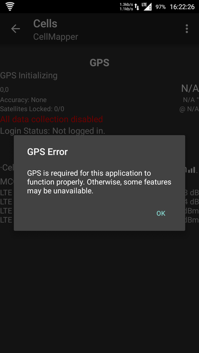
GPS Error
GPS virhe johtuu siitä että GPS ei ole päällä. Ota se käyttöön matkapuhelimen asetuksista. Cellmapper ei pysty mittaamaan ilman GPS. Mittauessa kannattaa varmistaa että etusivulla on GPS Fix OK. Tämä varmistaa että data on oikeanlaista. Googlen sijaintipalvelu ei ole sama asia kuin GPS.
Sijaintipalvelut voi ottaa käyttöön Samsungissa: Asetukset -> Sijaintipalvelut -> Käytä GPS sateliittejä.
